
During the first half of the fifteenth century, a time when Muslim merchants could travel virtually unobstructed from Morocco to Southeast Asia, and navigators from Ming China could boast of enormous naval expeditions reaching as far west as Hormuz, Aden, and Mombasa, Western Europeans remained almost totally confined, both physically and intellectually, to a small slice of the world bounded by the North Atlantic and the Mediterranean. Even as late as the eve of Columbus’s first voyage, European knowledge of other world regions continued to be based on a handful of sketchy medieval travelers’ accounts and a few dusty maps and geographical texts only recently recovered and translated from ancient Greek. In this sense, European exploration was possible in large part because Europeans had so much more of the world left to explore.” Giancarlo Casale, in The Ottoman Age of Exploration.[1]
Ibn Majid, 15th Century
Ahmed Ibn Majid belonged to a family of navigators. Both his father and grandfather were mu’allim, or masters of navigation, knowing the Red Sea in detail. Ibn Majid knew almost all the sea routes from the Red Sea to East Africa, and from East Africa to China. He wrote at least 38 treatises about those, some in prose, others in poetry, of which 25 are still available. These talk about astronomical and nautical subjects, including lunar mansions, sea routes, and the latitudes of harbours.[2]
His most famous book, written in 1490, was an encyclopaedia of navigational information called Kitab al-Fawa’id fi Usul ‘ilm al-bahr wa al-Qawa’ed, or Book of Useful Information on the Principles and Rules of Navigation. In it he dealt with the fundamentals of sailing, along with the monsoon system and the details of local winds, and how to navigate using the stars. From his own experience, he also included the locations of ports from East Africa to Indonesia.
 Ahmed Ibn Majid from 1001 Inventions ‘Journeys from a Golden Age’ animated trailer (Source)
Suleiman al-Mahri, 16th Century
Suleiman al-Mahri flourished early in the 16th century. His work is particularly well outlined by historian Fuat Sezgin.[3] In the fourth chapter of his Minhaj al Fahir, Al-Mahri informs us that his mathematical configurations of the Indian Ocean had been accepted in the Muslim world, helping seafarers to better gauge distances. One section is exclusively devoted to distances between the east coast of Africa and Sumatra-Java; in it, he lists 60 distances between headlands, gulfs, islands, and ports in the Indian Ocean that are located on the same geographical latitudes.[4]
Piri Reis, 16th Century
Piri Reis’s book of sailing instructions, Kitab-i-bahriyye, is known in translation by three names: The Book of the Mariner, The Naval Handbook, and The Book of Sea Lore. It has been recently re-published, and this new printing includes a color copy of the original manuscript, with the Ottoman text translated into Latin, modern Turkish, and English.[5]
The Book of Sea Lore by Piri Reis is a mariner’s guide to the Mediterranean. It gave sailors instructions for navigating and good knowledge of the Mediterranean coast, islands, passes, straits, bays, including where to shelter in the face of perilous seas and how to approach ports and anchor. It also provided directions and precise distances between places.[6] It is the only full and comprehensive manual covering the Mediterranean and Aegean Seas ever made, with 219 detailed charts.
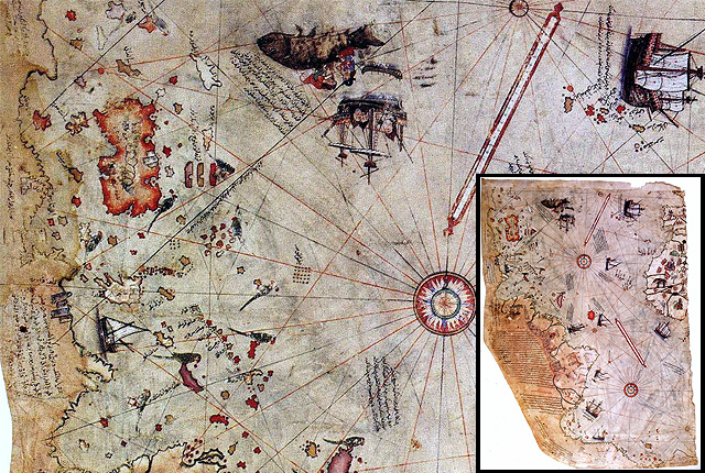 Piri Reis’s World map, 16th century
(Source: and 1001 Inventions: The Enduring Legacy of Muslim Civilization, 3rd edition, page 245)
There were two editions of the handbook; the first came out in 1521, the second five years later. The first was primarily aimed at sailors; the second, on the other hand, was a gift from Piri Reis to the sultan. It was full of craft designs, its maps drawn by master calligraphers and painters, and already in the 16th century it had become a collector’s item. For more than a century, copies were produced, becoming even more luxurious. Historian William Brice observes that Kitab-I Bahriye provides “the fullest set known to us of the kind of large scale detailed surveys of segments of coast which, by means of joining overlaps and reduction to a standard scale, were used as the basis for the standard Mediterranean Portolan outline.[7] Interestingly, the book also referred to European voyages of discovery, including the Portuguese expedition to the Indian Ocean and Columbus’s discovery of the New World.There are around 30 manuscripts of this Book of Sea Lore scattered all over libraries in Europe, but most are of the first version.[8]
Piri Reis should not be confused with the Ottoman Admiral and scholar Seydi Ali Reis.
Zheng He, 15th Century
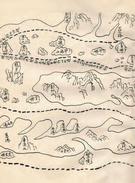 Fifteenth-century Zheng He and his crew used this navigation chart to chart the routes taken during his voyages (Source: and 1001 Inventions: The Enduring Legacy of Muslim Civilization, 3rd edition, page 255) Fifteenth-century Zheng He and his crew used this navigation chart to chart the routes taken during his voyages (Source: and 1001 Inventions: The Enduring Legacy of Muslim Civilization, 3rd edition, page 255) |
Zheng He (1371-1435) became the Admiral of the Chinese Fleet. He navigated to Mecca, the Persian Gulf, East Africa, Ceylon (Sri Lanka), and Arabia decades before the journeys of Christopher Columbus or Vasco da Gama.
His 62 capital ships, each of which weighed in at 3,417 stons (3,100 metric tons), dwarfed those of Columbus’s ship, which weighed about 100 tons (91 metric tons).[9]
During 28 years of travel, Zheng He’s ships visited 37 countries, making seven far- reaching sea voyages in the name of trade and diplomacy.
This followed the decision of Ch’eng Tsu (Yung Lo), the third Ming Emperor, to launch a total of seven naval expeditions from 1405 to 1433.[10]
The expeditions covered a distance of more than 31,000 miles (50,000 kilometres), and his first fleet included 27,870 men on 317 ships.[11] Sailing with such a large fleet into largely unknown waters required great skills.
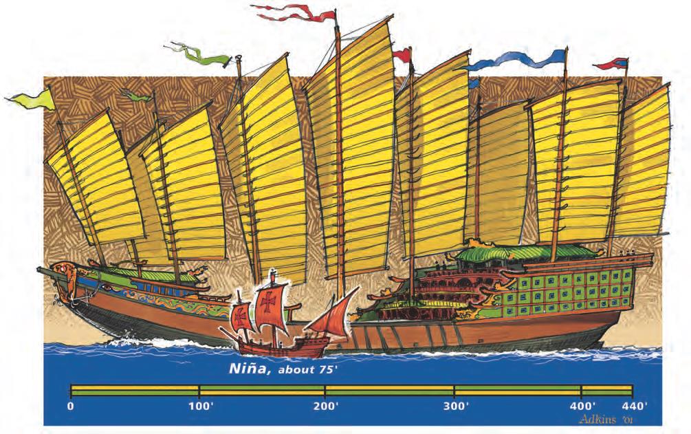 A rendering compares Christopher Columbus’s boat, which was 23 meters (75 feet) long, with Zheng He’s boat, which was 134 meters (440 feet) long (Source: and 1001 Inventions: The Enduring Legacy of Muslim Civilization, 3rd edition, page 256)
Zheng He made seven great “Treasure Ship” voyages, which took him to many places, including Java, Palembang, Malacca, Sumatra, Calicut, Arabia, Aden, East Africa, and Egypt.[12] The last expedition went as far as Jeddah in the Arabian Peninsula. It was then that a small group of Chinese Muslims went to visit Makkah.[13] During the voyages, there was scientific discovery and the search for gems, minerals, plants, animals, drugs, and medicine, which became increasingly important as the voyages multiplied.
 A stone statue of Zheng He stands in Nanjing’s Zheng He Memorial Hall.
(Source: and 1001 Inventions: The Enduring Legacy of Muslim Civilization, 3rd edition, page 254)
Get the full story from 1001 Inventions: The Enduring Legacy of Muslim Civilization Reference (4th Edition) Annotated.
www.amazon.co.uk/1001-Inventions-Civilization-Reference-Annotated-ebook/dp/B0775TFKVY/
References
[1] Giancarlo Casale, The Ottoman Age of Exploration (Oxford University Press, 2010), Introduction, 5.
[2] J. Lirola, Arab Navigation in Medieval Science, Technology and Medicine: An Encyclopaedia, T. Glick, S. J. Livesey, F. Wallis, eds. (London: Routledge, 2005), 364-66, at 365-66.
[3] F. Sezgin, The Istanbul Museum, op. cit., 94.
[4] Ibid.
[5] Piri Reis, Kitab-I Bahriye, 4 Vols., Ertugrul Zekai Okte, ed., trans. by Vahit Cabuk, Tulay Duran, and Robert Bragner, Historical Research Foundation-Istambul Research Centre (Ankara: Ministry of Culture and Tourism of the Turkish Republic, 1988-91).
[6] S. Soucek, A Propos du livre d’instructions nautiques de Piri Reis, in Revue d’Etudes Islamiques, Vol. 41, 241-55, at 242.
[7] W. Brice, Early Muslim Sea-Charts, in The Journal of the Royal Asiatic Society (1977), 53-61, at 56.
[8] A. Soucek, A propos, op. cit., 244-45.
[9] J. M. Hobson, Eastern Origins of Western Civilisation, 144-45
-L. Suryadinata, Admiral Zheng He and South East Asia, Institute of South-East Studies (ISEAS), International Zheng He Society (Singapore, 2005).
[10] C. A. Majul, Islam in the Philippines and its China Links, op. cit., 10.
[11] William Willets, The Maritime Adventures of Grand Eunuch Ho, Journal of Southeast Asian History, Vol. V, No. 2 (September 1964), 26.
[12] Hsu Yun-tsia, Notes relating to Admiral Cheng Ho’s Expedition, in L. Suryadinata, Zheng He, op. cit.,124-35, at 131-33.
[13] C. A. Majul, Islam in the Philippines and its China Links, op. cit., 10.
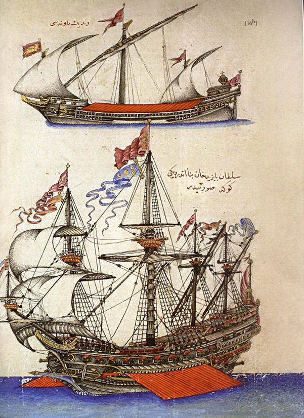 An Ottoman “Goke” ship manuscript from “The Gift to the Great Ones on Naval Campaigns by Kâtib Çelebi” (Source)